• Welcome to the Fantasy Writing Forums. Register Now to join us!

Anybody care to share their map?

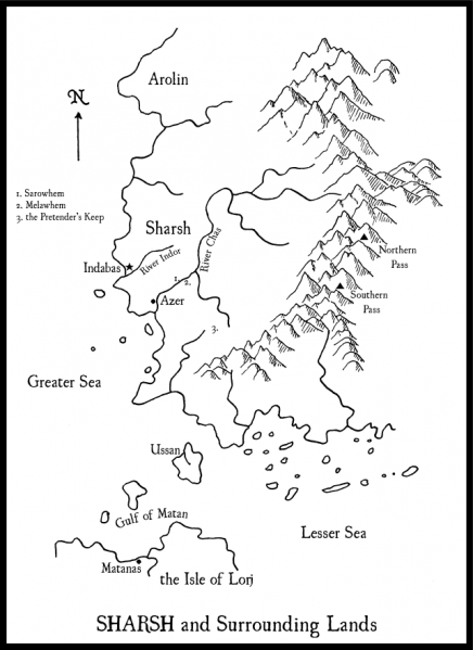
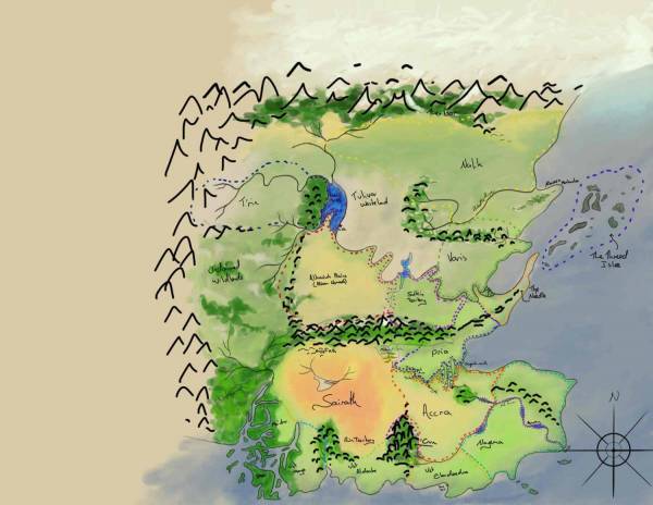
The thing I love about this map is its simplicity. It's clean, to the point for the story (I assume) without a lot of extra info that might not be needed for the story. Your map would also look good for an e-book, at the smaller scale, due to its simplicity.

I'm currently working on an expansion of a map, really just a blowup of one small part of a map that will be the location of a smaller scale story--but I always seem to want to put more and more and more on it, heh.

This is the map that goes (more or less) with my novel coming out in June, 'The Crocodile's Son.' This hand-drawn version will probably not be the one that goes in the book. I scanned my drawing — the outlines, rivers, mountains — into Corel Draw (my graphics program of choice) and added the text and some refinements.

sharshdrawnnet.png
 

elemtilas

Inkling
The thing I love about Insolent Lad's map is its simplicity. It's clean, to the point for the story (I assume) without a lot of extra info that might not be needed for the story. Your map would also look good for an e-book, at the smaller scale, due to its simplicity.

De gustibus, I suppose. Agree about the clean lines and so forth. The font chosen is very pleasant, and the mountains are nicely shaded. But for me, this map is but a starting point. It's too empty! There's clearly nowhere near enough information given: no borders, no roads, the mountain ranges aren't named. No towns or regions named. Those are the kinds of things that have readers drawn into the world and asking, well about XYZ...where do they come into the story!? Where does that road go, and who lives there and what tales come from their lands?

I'm currently working on an expansion of a map, really just a blowup of one small part of a map that will be the location of a smaller scale story--but I always seem to want to put more and more and more on it, heh.

More is best!
 

Insolent Lad

Maester
I've learned to keep my maps simple for inclusion in a book. More detail is simply lost fitting it on a 6 by 9 page, and a cluttered, unreadable map is worse than no map at all.
 
I forget I have this map and I don't think I uploaded it here yet. But -slides it into this thread-


I made this map as an in world source for the Ocsolis Dominion. They are attempting to standardize everything so the world is simply called 'the world' . Names of physical places are a little harder to standardize so they still call them by their old names.
 
Just an update: Inkarnate now offers a commercial license. It's a yearly subscription model, but according to a comment left on their Facebook page, any map created during a paid subscription period is usable after the subscription has ended.

Well, son of a bitch. Inkarnate won't let me use the map I built. Since it's beta, they won't let me publish it. I'll have to build it all over again in GIMP. At least I know what I'm doing this week.
 

RedAngel

Minstrel
Here is a style I am not toying with.

Arahmah%20Base%20Map%20Names.jpg


I went back and added a layer of my map behind my territory map. I plant to continue working on it when I get time to extend it and to add names to the empires on the map itself at some point.

Arahmah2.gif
 

Ruru

Troubadour
Loving all these maps! Can't stop watching @RedAngle's territory map, its fascinating. I do find that there is a bit of an art to producing a map that works well in a printed or e-book: too much detail and its hard to read in such a small image, but then it also isn't satisfying. I want to know about all the other things the world I'm reading about holds!

While I have a good few trustworthy 'planning maps' like Lisselle's tea-stained beauty, I have drawn up a fuller version, mostly so I can see on paper what I'm working with in my head. I've used this map to plan cultures, roads my characters will take, the landscape they might have to go through, particularly to help with my own consistency further down the line!

This was drawn in Sketchbook, and is normally quite big so I can zoom around it a bit. It doesn't have all the details yet, but thought I would share it anyway :).

book_Map.jpg
 
Last edited by a moderator:

elemtilas

Inkling
This is a map of Eosphora, a part of one of the great landrealms, or continents, of Gea. Cartographers *there* use a 288deg circle, and this map shows about 9degE to 44degE and 12degN to 36degN. Orientation is East uppermost. It's definitely not intended for inclusion in a trade paperback sized book!

eosphora_by_elemtilas-dbakb7z.jpg
 

Mythopoet

Auror
@elemtilas your map is so very Tolkien-esque! It's beautiful and I love it.

My map is essentially this:

Ptolemy_Cosmographia_1467_-_world_map.jpg


Which was a world map made by Claudius Ptolemy around 150 AD. (Though the above is a later, redrawn version.)
 

elemtilas

Inkling
@elemtilas your map is so very Tolkien-esque! It's beautiful and I love it.

Thanks much! Yeah, there's a pretty clear line of inspiration from Tolkien's map making to mine!

My map is essentially this:

Ptolemy_Cosmographia_1467_-_world_map.jpg


Which was a world map made by Claudius Ptolemy around 150 AD. (Though the above is a later, redrawn version.)

Now that's cheating! You got one of the most renown cartographers ever to draw your map for you! :D

These maps are delicious indeed! So much blue! Phantom islands! Phantom seas!
 

Noxius

Dreamer


My first finished map :) It is just a realtivley small part, an island namend Ilaendrin that is around the size of Borneo, but I'm pretty proud of it (and I'd love to hear some feedback!)
 
Last edited:

elemtilas

Inkling

I like the shading in the mountains --- that's very nicely done! I would note to be careful of rivers ending in lakes, though. It does happen, of course, if a river heads towards a depression from which there's no outlet. Unless there's sufficient evaporation of the lake water, it will eventually spill over the lip somewhere and an exit river will form.

I notice that you have two of these, and that the northernmost is ever so close to another river system. I can buy the southern one existing for a while, but the northern one seems less likely to exist.
 

RedAngel

Minstrel
When I was living in the suburbs near Chicago we used to take our boat out on the Fox River and due to the glacial topography around the area the Fox was connected to multiple lakes that the river snaked through. The river could be mostly dry during the summer months and maintain a lake or spill over into the nearby river when there is wetter months.
 

Noxius

Dreamer
I would note to be careful of rivers ending in lakes, though. It does happen, of course, if a river heads towards a depression from which there's no outlet. Unless there's sufficient evaporation of the lake water, it will eventually spill over the lip somewhere and an exit river will form.

I notice that you have two of these, and that the northernmost is ever so close to another river system. I can buy the southern one existing for a while, but the northern one seems less likely to exist.

In my head, the south-eastern part of the island is pretty high and has cliffs instead of shores, so I thought it would be logical that the river found some lower point there and filled it up, while the evaporation prevents it from spilling over.

I could make the lake in the north spill over and then connect with the river next to it. Would that be more realistic?

Thank you all for your replies!
 

TheKillerBs

Maester
More likely, yes. More realistic? The set-up you have there is already perfectly realistic. You could have a salt lake in the south and then the northern one could drain into the neighbouring river system via an underground river.
 
Last edited:

RedAngel

Minstrel
IMO it is geographically intersting to leave it though I would add a touch of shading that shows a potential connection without having it actually connect that would show that at points in time it does connect.
 
Top