Miskatonic
 Auror
Auror
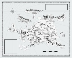
Well my commissioned map is all completed so I thought I'd share it with everyone. I'm very pleased at how it turned out. ")
Enjoy

Enjoy


Are those islands on the left supposed to look like the British Isles? Because they do.
Sick map though.


That looks perfect.
If it takes up two pages, would you need to make it a fold out so that the spine doesn't hide parts of the map or would you just split the whole map in half and print separately?
Commissioned ... from whom?
(I'm shopping maps and map-makers myself)

A very useful map, Miskatonic.
I spent a few full weekends drawing my continent map using mostly Gimp and various brushes to get the mountains and forests and seas looking great. Whole thing looks a lot like a charcoal drawing. I see you included roads, which was something I haven't included on mine. I also don't have national borders–but that's because there aren't any on mine. (There are regional borders, since the empire is subdivided into administrative districts, but I haven't drawn those demarcations either.)
I drew a separate map for one particular small island which will figure heavily into the story.
I'm very, very happy with my maps but I have a serious problem. I need to do detailed maps of at least the capital city, since a lot takes place there, and perhaps maps of some large towns on that island. My geographical continental map is pretty good, I think, but drawing down into the cities/towns seems a lot more complicated to me. Part of my problem is simply that I haven't given enough thought to the many details of the capital city or even the towns on the island. I don't need a map of those, but for whatever reason I'm a little irritated not having them. (And I'm already planning to use this world for multiple stories, so...)
If anyone has questions about the map itself or the map making process, feel free to ask.
Voldenskagg and Nytt Voldenskagg I would assume is Scandinavian influenced. I reckon you're planning to put fantasy vikings there?
