• Welcome to the Fantasy Writing Forums. Register Now to join us!

Calling all geography/climate experts

OGone

Troubadour
I've made at least thirty maps but I think I've finally made one which makes sense geographically and allows me to tell the stories I want to, it took a while to balance the two things. I've done a rough plot of my continents and scribbled some important stuff on.

Now one thing I do need to do is move everything north of the equator up a little, apart from that I'm looking for any advice I can possibly gather on what could possibly be wrong with my map. I've done plenty of research on biomes and think I've constructed something workable but am still not sure. So before I go ahead and make a clean version and start adding rivers, cities etc need some advice.

Also looking to see if my mountains are placed correctly in regards to my tectonic plates.

Here's the map:
(Map is too big to post so click here for link.)
and a short disclaimer: it is very... scribbly.

The red line is my equator, the faint black lines are the tectonic plates.
The dark patches are mountain ranges.
To give some scale the largest island on the right is about 700 miles wide at its longest.

I want to make sure all biomes are arranged correctly in correlation to position and the mountains.

Any advice or misc comments would be great!
 
Last edited:

mbartelsm

Troubadour
Normally, biomes are evenly distributed along certain longitudes, the -15º to 15º area tends to have high humidity and heat; 15º to 45º / -15º to -45º tends to be hot but dry, hosting many deserts; 45º to 75º / -45º to -75º tends to have temperate climates; and (-)75º to the poles is arctic. These can vary depending on the geography, for example, a mountain range between the ocean and flat land will create and effect which's name I can't recall where the area behind the mountains will get little to no rain, making it a desert.

But, if the world works for your story, I see no reason to change it.
 

OGone

Troubadour
Isn't this what I've done though? Just imagine the two southern islands, four smaller rainforest islands and the equator are moved down a little so the sea encompasses the 15º to 45º deserts.
 
Last edited:

ThinkerX

Myth Weaver
Hmm...I'm assuming the the rainforest on the 'western' island continent is at the bottom of a deep valley or canyon. Otherwise, the desert and forest are in too close a proxemity to each other.

Also...unless there are some other land masses to the south, the southern shores of the southern sland contients are likely to be wetter than your map key indicates - or at least prone to major stormes.
 

mbartelsm

Troubadour
Isn't this what I've done though? Just imagine the two southern islands, four smaller rainforest islands and the equator are moved down a little so the sea encompasses the 15º to 45º deserts.

Mostly, the issue is with the grasslands and forests in desert latitudes on the north-eastern continent
 

OGone

Troubadour
Okay I've had another stab at it. The problem is I need a couple rainforest islands between the southern and western continent, is there any way this could happen at all and be explained?
 

Addison

Auror
Your mountains are good, they're where two plates meet.

The only thing that I saw needing change or thought it your Desert/Canyon island. Deserts are barren, dry arid lands far from open water. And aside from the Outback I don't believe deserts exist below the equator.
 

Nihal

Vala
Your mountains are good, they're where two plates meet.

The only thing that I saw needing change or thought it your Desert/Canyon island. Deserts are barren, dry arid lands far from open water. And aside from the Outback I don't believe deserts exist below the equator.

250px-Caatinga_IBAMA.jpg


world.gif


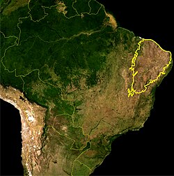
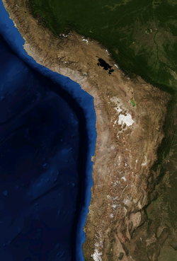
Caatinga. It exists mostly due the mountain range blocking clouds coming from the ocean. During the rainy season it turns green, during the dry season it's basically a desert. There are also other deserts in the Andes mountain range, like Atacama... the driest desert of the world.

250px-Atacama.png


I won't even point the deserts of Africa. :p
 

OGone

Troubadour
Right, I've gone a different route. I've used the climate key on the map here rather than naming biomes.

Still need to add my mountains and two more continents.

There can be so many reasons for a climate to be why the way it is and a lot of that is not necessary for the stories (they just need to be there). However, when you go completely ridiculous and put rainforests in weird locations, they need some explaining.

Here's map V2, I think everything is placed fine now as I used the real world map to line the climates up. HOWEVER, the two north-western rainforest islands are absolutely integral to my story... Can anyone explain some phenomenon how these could possible occur?

qx2mg7.jpg
 
Last edited:

ThinkerX

Myth Weaver
Here's map V2, I think everything is placed fine now as I used the real world map to line the climates up. HOWEVER, the two north-western rainforest islands are absolutely integral to my story... Can anyone explain some phenomenon how these could possible occur?

Yep. And there is a real world example to go off of: the pacific northwest - northern california, oregon, washington british columbia, and SE alaska. What you'd have would be a powerful offshore current and a 'gulf stream' type atmospheric effect which would be funneling *lots* of moisture to that coastal fringe. This would work best if these islands are mountainous, or at least bordered by mountains to the east, acting as a sort of moisture trap. Get inland from that, and you start hitting drier country in a hurry.

One other detail which may or may not interest you - said ocean current is liable to bring along all kinds of interesting things from far off places with it. Your cultures on the islands are about 99% certain to know of the existence of said ocean current, which may even figure into their mythology somehow.
 

OGone

Troubadour
Yep. And there is a real world example to go off of: the pacific northwest - northern california, oregon, washington british columbia, and SE alaska. What you'd have would be a powerful offshore current and a 'gulf stream' type atmospheric effect which would be funneling *lots* of moisture to that coastal fringe. This would work best if these islands are mountainous, or at least bordered by mountains to the east, acting as a sort of moisture trap. Get inland from that, and you start hitting drier country in a hurry.

One other detail which may or may not interest you - said ocean current is liable to bring along all kinds of interesting things from far off places with it. Your cultures on the islands are about 99% certain to know of the existence of said ocean current, which may even figure into their mythology somehow.

Thanks a lot for this, I've a few questions though. The problem is they're between two continents, the shore would have to funnel through between them - wouldn't this result in rainforest along the coasts? I didn't fully understand how the mountains worked in this, where would the mountains have to be positioned on the islands (they're volcanic islands situated on tectonic faults, so this works fine for me). Really I need help with the actual map, it's a big ask but could you possibly just scribble an arrow on or describe to me how these currents would work?

+ would I have to move the savannah island out from between them and place it somewhere else?

Not sure how I can incorporate the second part but it is interesting, I'll try to figure something with it. Really helpful post Thinker, thanks.
 

ThinkerX

Myth Weaver
Hmmm...

1) I was under the impression that your pair of rainforest islands were the green islands in the middle/top left of the second map. If so, no problem: the situation is still very much like coastal BC or SE alaska - lots of rain, and some very large heavily forested islands. IF not, post your mao anew with these islands circled and I'll take another peek.

2) Yes, along the immediate coast, you would have an extensive forested region. This is where the mountains along the shoreline come in - they would act as a sort of partial moisture trap. With western north america, you have (coastal) oregon and washington and BC - very wet, heavily wooded; then the Rocky Mountains, and once across the mountains, a huge desert (eastern washington, oregon, and further inland the likes of utah).

3) Yes, you would have to move your savannah - to the eastern region described in point 2. It would essentially become the equivilent of the great plains region in north america.
 

OGone

Troubadour
Here's the new map with some alterations and I've circled the two rainforest islands I need. Also added the mountains in the positions I need/think are correct. If you spot anything wrong go ahead. The two islands I need to be rainforest are separated, need an explanation as to why they're both like that if possible - where could I put the mountains? The islands themselves are mountainous/volcanic btw.

qsv2tj.jpg


Thanks for your help so far everyone.
 

ThinkerX

Myth Weaver
Hmmm...the smaller of the two islands would work pretty well. The other one...not so good. Would it work for your story if you changed it out with the island of similiar size to the north of the small one?

I'm assuming that the brown lines are mountain ranges. For the climate scheme I described earlier to work, those mountains - at least on the NW continent - would have to be right on the coast, running north and south.

Possible alternative location for the second (larger) rainforest isle: move it north, so that it is 'cupped' by the coast, and put mountains running parallel to the coast on the mainland. In this case your island, while not tropical, would still be fairly warm because of a warm water current coming in from the south. (moving clockwise along the coasts)
 

mbartelsm

Troubadour
I see no major problems, I forgot that easter side coasts often get large amounts of rain due to warm oceanic currents, that could explain the rainforest continent.

If you want to refine it a bit more then take a look at this: The Climate Cookbook
 
Top