• Welcome to the Fantasy Writing Forums. Register Now to join us!

Anybody care to share their map?

Noxius

Dreamer
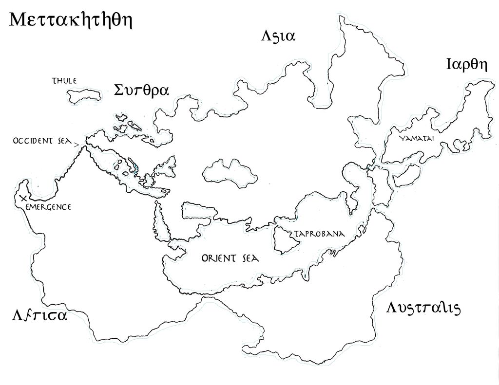
Thank you both! I'm happy that I got everything right, I'm a little perfectionist, so I looked up a lot about maps and geography (I even started with where the tectonic plates lie under this specific part of my world)

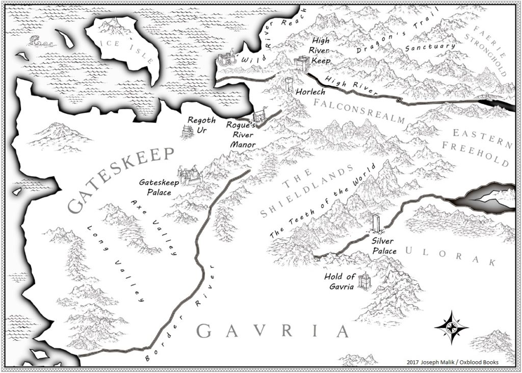
Shading and making the impression that it only connects in the rainy times of the year is a good iodea, I will try to do that. :)
 

elemtilas

Inkling
More likely, yes. More realistic? The set-up you have there is already perfectly realistic. You could have a salt lake in the south and then the northern one could drain into the neighbouring river system via an underground river.

This is true.

My point is that both the northern lake and the river exist close by in the same hilly region, and there doesn't appear to be any intervening highlands. Ergo, it seems like the lake ought to spill over towards the east (away from the higher hill lands).

The idea of a basin in the is entirely reasonable. Given that most of the island seems to be wooded, I suspect that the local climate is moist to wet --- not really ideal for sufficient evaporation to occur.
 
My Songsphere cosmos unfortunately has no map, because the distances between planets are insane. I've made a small list of planets and realms, though:

Mythaven [ascended aspect = Omniad]
Oeuyia [ascended aspect = Incarnachant]
Where Realms--Somewhere, Nowhere, Everywhere, Anywhere, and Somewhere Else
The Alpha-Omega Dimension [also known as Wyrdness]
 

elemtilas

Inkling
Here is the continent of Voldenne, in the world of Io. :^)

Voldenne (continent W.I.P.) by Iosmovaehar on DeviantArt

Alright! Spill the beans! What's with Ardra Voþ? A nice circular feature like that generally either means a whale of an asteroid strike or evidence of some ancient alien mining activity. Or perhaps some crank alien dude bent on galactic domination has tested his death ray on this planet!


Some of the rivers look a bit off, though: those two rivers over in Loraiþeeen seem to go nowhere; also the short branching rivers over in Aimuridiiu séem to arise in the Yaral Mountains and flow westwards. Rivers cán split in the direction of flow, but it's extremely rare, and here you've got two that seem to split thrice. Also, they don't seem to flow into the sea. Like the more western rivers, they seem to end up nowhere. I'm just curious if there's a good reason for that behavior (that I may not be aware of), or are they just something of a sketch that's going to be worked on & edited later?

In any event, a nicely done map!
 

Iosmovaehar

Acolyte
Thanks!

Ardra Voþ (pronounced "Adra Voth" - which translates to "The Deep Forest" in the Angoseir language) is where the first creature to ever live in Io entered the world. None now know exactly how it entered Io, or for what reason, but clearly from deep crater left in the landscape, the event itself must have been catastrophic. The Ancient One, The First One: The Watcher Who Wants Not to be Watched entered the world of Io long before any other life. The Watcher has since moved itself - far away from the prying eyes of civilization, now dwelling deep beneath the old bridge of Taav'n Diir ("Tayvin Dire"), within the bowels of the earth; in the Great Chasm - where it restlessly watches the rest of the world... and perhaps influences it from time to time. The Watcher can see all things in the world of Io. But, this does not make it all-knowing. It's all-seeing eyes can see but one thing at a time; it's vision does not extend to multiple places at once. So it sits lying in wait, vigilantly watching for any threat that could intrude upon it's solitude.

Once widespread across the continent of Voldenne, the towering Bellbulb Trees - whose great dangling flower bulbs hang down like chandeliers from viny tendrils that can stretch for tens, sometimes hundreds of feet - are the dominant mega-flora in the crater forest of Adra Voth. Bellbulbs can now be found in only two places across Io: the forest of Adra Voth being one of them. Among the creatures of Adra Voth live the Nydhar (literally "deer-people" in Angoseir), a nomadic race of cervitaurs (centaurs, but half-deer instead of half-horse) who hunt and gather within the crater forest.

The northern tip of Adra Voth - beyond the Bonewall - is where the great drake-like, flying sverinaen build their nests; and it is for the precious hatchlings within these nests that these flying behemoths hunt, and hunt often. Some sverinaen prefer marine prey, living life like lumbering pterosaurs barreling across the sky, skimming the water for fish. Yet others prefer to glide from tree to massive tree within the deep wooded glades of Adra Voth, hunting for any prey that they may find. The Nydhar fear the sverinaen more than anything else, and have over the years killed a handful. The defeat of a sverinaen is the greatest triumph that a tribe of Nydhar can achieve, and upon taking down the lumbering giant, it's meat is distributed among the tribe; and it's bones are carried to be added to The Bonewall, which the Nydhar have constructed over countless generations to separate their portion of Adra Voth from the nesting grounds of the sverinaen.

Thank you for noticing the issues with the rivers in Amuridiiu ("Ammeridia") - which I indented to be a fairly swampy area that is homeland of the Amerridian peoples, hence why the region is quite waterlogged. I will have to fix that. Geology is a huge point of ignorance of mine!
 

Mythopoet

Auror
I've been putting some work into my map. Ptolemy's map was my starting point, but I wanted to add some additional lands. I've only added a few labels so far though. The font for the larger land masses is a bit hard to read. It's supposed to be Greek-esque. The world name is Mettakhthon.

Mettakhthon%203_zps1eai2qmc.jpg
 

elemtilas

Inkling
I've been putting some work into my map. Ptolemy's map was my starting point, but I wanted to add some additional lands. I've only added a few labels so far though. The font for the larger land masses is a bit hard to read. It's supposed to be Greek-esque. The world name is Mettakhthon.

Mettakhthon%203_zps1eai2qmc.jpg

Um. About the "Greekesque" thing. How am I supposed to read that? Sugthra? Lwtisa? My opinion only, but it's terribly annoying! I would just suggest using the Greek values for the letters and leave it at that. Sufficiently ancient and mysterious without making people try to decipher what you mean by each letter. Also, the Greek alphabet has the built-in feature of inherent Greekesquery! You don't actually have to fake it!

Otherwise...love the ptolomean projection and the ptolomean shape of the continents. Hopefully we'll see more lands labelled and described soon!
 

Mythopoet

Auror
Um. About the "Greekesque" thing. How am I supposed to read that? Sugthra? Lwtisa? My opinion only, but it's terribly annoying! I would just suggest using the Greek values for the letters and leave it at that. Sufficiently ancient and mysterious without making people try to decipher what you mean by each letter. Also, the Greek alphabet has the built-in feature of inherent Greekesquery! You don't actually have to fake it!

Otherwise...love the ptolomean projection and the ptolomean shape of the continents. Hopefully we'll see more lands labelled and described soon!

lol I was just using this font for fun. Obviously in anything I publish I would make sure it is legible! But I happened to have this font on my computer and thought it looked cool.

Anyway, the continents are Europa, Asia, Africa, Australis and Iapon (Japan). Names not final. I referenced a 16th century map of Japan, but drew it myself rather than outlining it directly (as I had with the Ptolemy) so it's different. And the Japan map was obviously not on the same scale as the Ptolemy so it ended up being huge. But I think I like that.
 

elemtilas

Inkling
lol I was just using this font for fun. Obviously in anything I publish I would make sure it is legible! But I happened to have this font on my computer and thought it looked cool.

Oh, yeah, definitely looks cool!

I guess just a personal gripe that the Greek letters aren't being used with their own values, but the Latin letters are.

Anyway, the continents are Europa, Asia, Africa, Australis and Iapon (Japan). Names not final. I referenced a 16th century map of Japan, but drew it myself rather than outlining it directly (as I had with the Ptolemy) so it's different. And the Japan map was obviously not on the same scale as the Ptolemy so it ended up being huge. But I think I like that.

No worries there!

Came out looking nice, in my opinion!
 

Malik

Auror
A new map for the hardcover release of Dragon's Trail. My wife made it with Campaign Cartographer, working off my previous map and notes.

Map-crop-1024x731.jpg
 

Drakevarg

Troubadour
"Ragoth Ur" seems a bit iffy. Literally one letter off from the name of the Big Bad of Morrowind (and by extension, the name of his citadel).

Edit: Oh, Regoth Ur. Slightly less iffy, but still.
 
Last edited:

Malik

Auror
"Ragoth Ur" seems a bit iffy. Literally one letter off from the name of the Big Bad of Morrowind (and by extension, the name of his citadel).

Edit: Oh, Regoth Ur. Slightly less iffy, but still.

1.) I had to look up what Morrowind was.

2.) Pretty sure I came up with that name when any modern game designers short of Chris Roberts were still fudging their Huggies.
 

elemtilas

Inkling
Pretty sure I came up with that name when any modern game designers short of Chris Roberts were still fudging their Huggies.

:Owned:

That made my day! Sooner or later, just by dumb luck, someone's going to come up with a name that sounds a lot like a name someone already came up with. It's happened to me several times. And in both directions.
 

Drakevarg

Troubadour
¯\_(ツ)_/¯

Everybody has their own point of view on what's 'common knowledge,' I guess. I used to date someone who had never heard of Clint Eastwood.

To me, it was the kind of like reading a crime drama where one of the characters was named "Pilsen Fisk" because the author either predated or had never heard of the Kingpin.
 

TheKillerBs

Maester
I am resurrecting this thread. This is a map of (one of) my WIP's continent. I projected it to a "globe" with NASA's projector tool, linked by CupOfJoe
here.

Imperialglobe.png


The cross-hatched area is the not-so-evil empire at its largest extent.
 

Malik

Auror
20171006_144849.jpg


The final version came out better than I expected. I'm contemplating selling these on my website.
 
Last edited:
Top