• Welcome to the Fantasy Writing Forums. Register Now to join us!

Thoughts on my Map?

Ban

Troglodytic Trouvère
Article Team
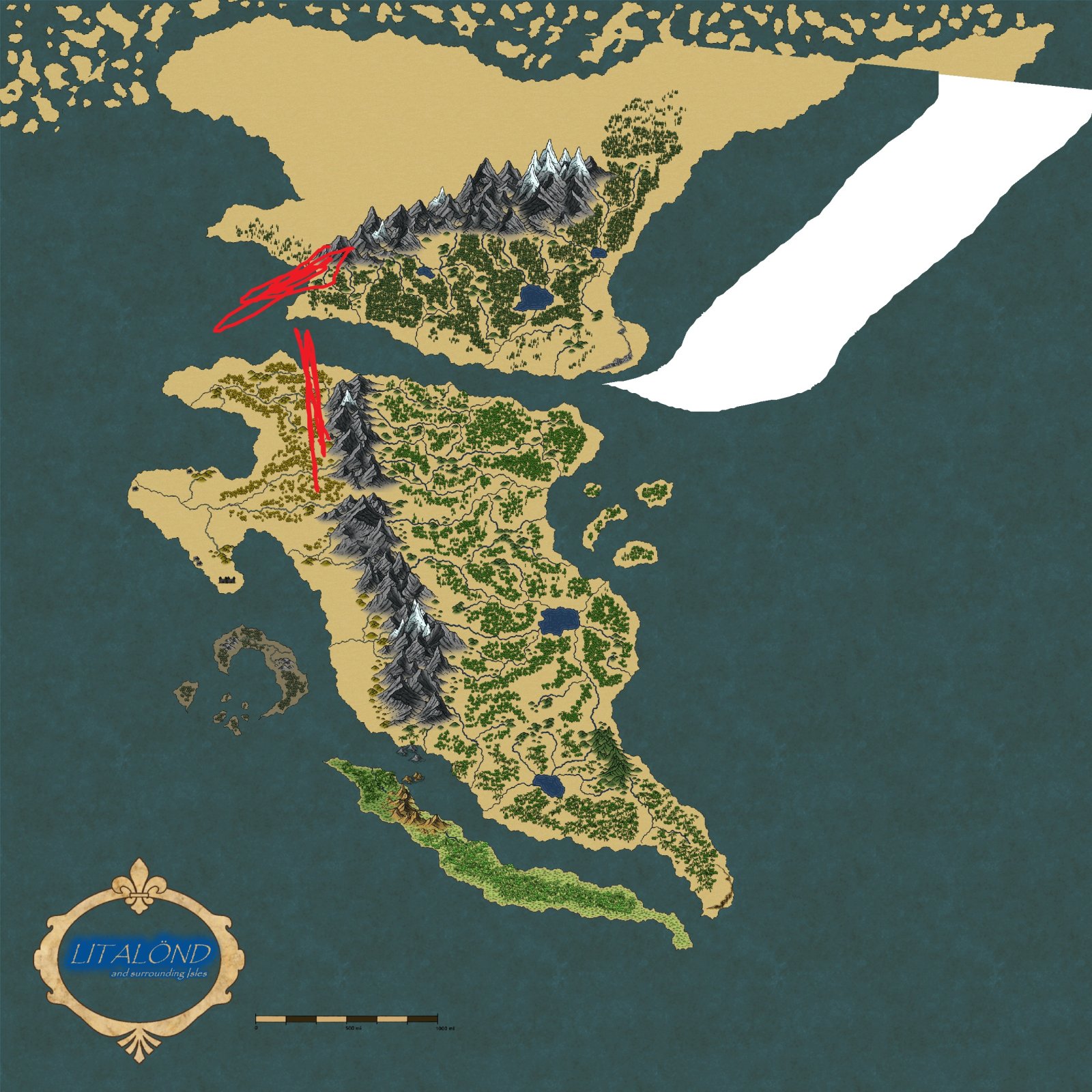
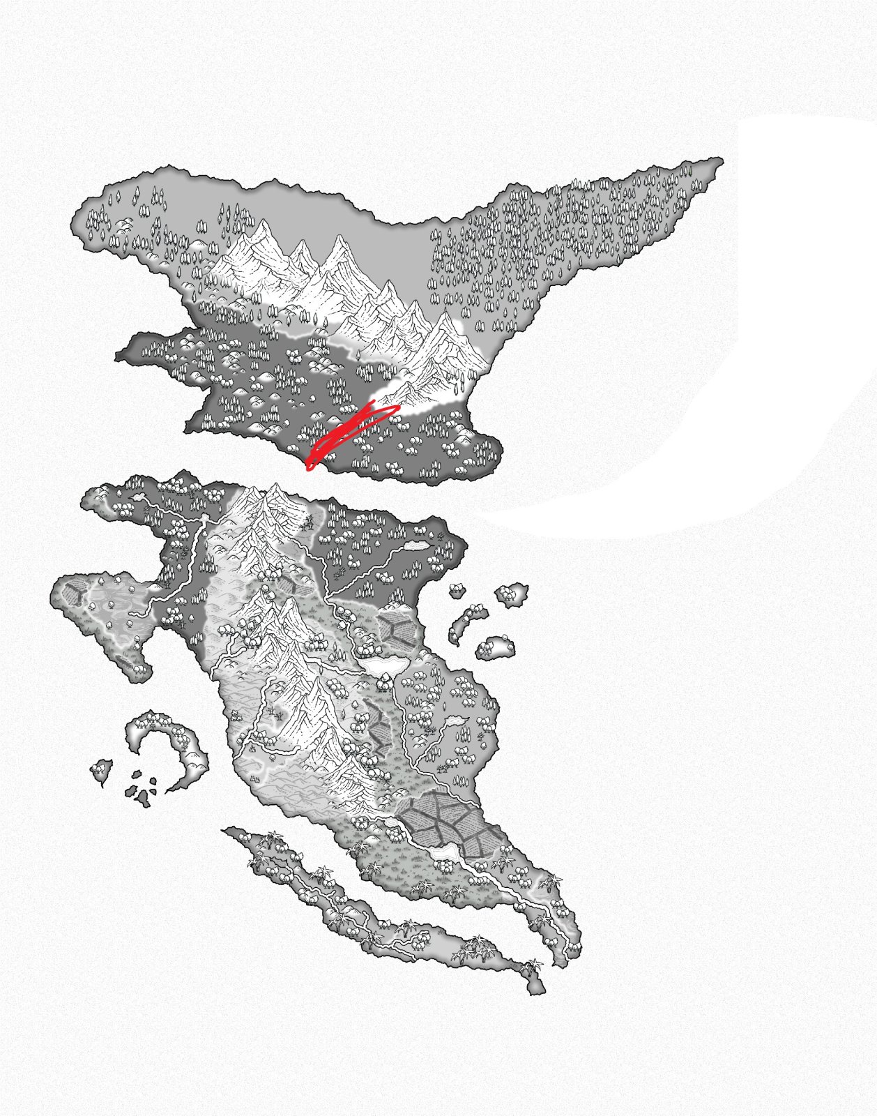
Makes sense to me. The mountain range was formed when the continents were attached, and they remain now that they have shifted. In addition to splitting from each other the continents have simply turned a little as well. From what I remember of the tectonics classes I snored through about a decade ago, that's all feasible. The mountains might realistically not be Himalayan in height, as I reckon they'd be further eroded, but eh, a little fantasy is permissible.

Edit: Nay, a little fantasy is mandatory!
 

TheKillerBs

Maester
Y'all aren't looking at the drift. It's easier to just show it

full

full


(9001 years in MS Paint later)

Also, in the new one, the mountain range stops in a bay, which looks very weird. Usually, mountain ranges go across peninsulae. There's no indication of a curve to join the two mountain ranges, so while you could imagine one, the lack of even hills hinting at one is... off.
 
  • Like
Reactions: Ban

sgbii

Minstrel
Y'all aren't looking at the drift. It's easier to just show it

full

full


(9001 years in MS Paint later)

Also, in the new one, the mountain range stops in a bay, which looks very weird. Usually, mountain ranges go across peninsulae. There's no indication of a curve to join the two mountain ranges, so while you could imagine one, the lack of even hills hinting at one is... off.
Fair point. I could throw a few more towards that southern peninsula to pronounce the curve more
 

Ban

Troglodytic Trouvère
Article Team
I can see it now. A slight adjustment there could indeed be good.
 

TheKillerBs

Maester
Whoa. I didn't even notice how the southern mountain range curves inward, putting it even further away from the line of the northern mountain range
 

ThinkerX

Myth Weaver
In terms of continental drift both mountain ranges work. The northern mountains formed because the plate south of them moved north - a situation much like the Indian Subcontinent, while the southern mountain range formed because that plate shifted westward. The one possible problem area would be how the southern mountains simply hit the northern shore and stop. My suggestion, given the forces at play would be to set a gargantuan volcano at the northern tip of the range, and a slew of spiky islands in the strait between the continent.

That arrangement would make for some interesting local sailor mythology - 'I am the mariner who braved the Straits of Hell, with fire on one side and reefs to the other!'
 

TheKillerBs

Maester
In terms of continental drift both mountain ranges work. The northern mountains formed because the plate south of them moved north - a situation much like the Indian Subcontinent, while the southern mountain range formed because that plate shifted westward.
Not really, the continental shape shows both northward and westward movement
 

sgbii

Minstrel
Updated Yet Again
How be this? I did a little more research to help get a better idea of mountain forming and rivers. I gave the mountains a slight s curve so they line up better, as well as adding lakes into a couple valleys. I also hand drew the rivers to better show their growth over distance.
 

Devor

Fiery Keeper of the Hat
Moderator
Updated Yet Again
How be this? I did a little more research to help get a better idea of mountain forming and rivers. I gave the mountains a slight s curve so they line up better, as well as adding lakes into a couple valleys. I also hand drew the rivers to better show their growth over distance.

It's really come a long way.

KillerBs point is still there, though. The mountains look like they line up and are part of one mountain range. But the islands used to be one landmass and have drifted apart. Once you move the islands back together, the mountains don't line up anymore. If they are part of the same range, they should line up when the islands are put back together, not as they are right now.
 

Foxkeyes

Minstrel
Nice map.

It could be an idea to drop in some islands in the area between continents. These islands could then become important conflict points between the continents.

Also, the mountain range in the northern continent is quite a bit away from the sea, while the southern continent's mountains end abruptly at the sea. Too abruptly, I think. It might be an idea to slope the southern mountains down to the sea. Then again, it does give a good natural boundary if you wanted to segment the southern continent. I guess it all depends on what you plan for the world.

I'm curious as to why you're creating the map. Is it for a story? Or a game, or just for fun?
 

sgbii

Minstrel
Nice map.

It could be an idea to drop in some islands in the area between continents. These islands could then become important conflict points between the continents.

Also, the mountain range in the northern continent is quite a bit away from the sea, while the southern continent's mountains end abruptly at the sea. Too abruptly, I think. It might be an idea to slope the southern mountains down to the sea. Then again, it does give a good natural boundary if you wanted to segment the southern continent. I guess it all depends on what you plan for the world.

I'm curious as to why you're creating the map. Is it for a story? Or a game, or just for fun?
Well it's kind of funny. So I'm working on a novel that I hope to expand into several books, the one I'm currently writing though takes place on the western peninsula that has the swamp in it. It's called Morland, or the Wastes to most other peoples.
 

Foxkeyes

Minstrel
Well it's kind of funny. So I'm working on a novel that I hope to expand into several books, the one I'm currently writing though takes place on the western peninsula that has the swamp in it. It's called Morland, or the Wastes to most other peoples.
Marshes are always interesting because each is unique and they offer so much scope for surprises. And they can change with the seasons, too, which offers greater unpredictability.

Have you a localised map for Morland-cities, farms, and the like. Sometimes when I'm creating a local map some of the more interesting locations emerge from the story as I'm developing it. It's another fun way to create maps.
 

sgbii

Minstrel
Marshes are always interesting because each is unique and they offer so much scope for surprises. And they can change with the seasons, too, which offers greater unpredictability.

Have you a localised map for Morland-cities, farms, and the like. Sometimes when I'm creating a local map some of the more interesting locations emerge from the story as I'm developing it. It's another fun way to create maps.
I haven't actually done that. At least not entirely. I did start to make one but I just wasn't happy with everything yet so I put it on hold until I've figured everything else out. As of right now though, the only things I'm 100% certain of is there is a massive Walled city called Whitestone on the southern coast on the ledges by the sea, and a larger fishing village turned into a trading post on the western coast called Ashen Shore. Most of the book takes place in Whitestone.
 

Foxkeyes

Minstrel
I haven't actually done that. At least not entirely. I did start to make one but I just wasn't happy with everything yet so I put it on hold until I've figured everything else out. As of right now though, the only things I'm 100% certain of is there is a massive Walled city called Whitestone on the southern coast on the ledges by the sea, and a larger fishing village turned into a trading post on the western coast called Ashen Shore. Most of the book takes place in Whitestone.
City maps are interesting, too. It's a good idea to sometimes put things on hold as they'll work themselves out in your head.

Good luck with the maps.

If you want any further feedback, drop me a line. I have some experience with world building.
 

Aldarion

Archmage
Looks OK, but mountain ranges shouldn't stop at the sea shore so abruptly (admittedly a mistake I've also made in my map) - rather in such a situation they are more likely to end up forming a peninsula.

I also don't understand why would there be a desert to the west of mountain in a narrow coastal strip? If anything, that area should be well irrigated (though I guess it might be theoretically possible if winds are exclusively east-west in that area? Not sure, but you should definitely check that).
 

Ban

Troglodytic Trouvère
Article Team
I also don't understand why would there be a desert to the west of mountain in a narrow coastal strip? If anything, that area should be well irrigated (though I guess it might be theoretically possible if winds are exclusively east-west in that area? Not sure, but you should definitely check that).
That's not a necessity. There could simply be a cold water ocean current akin to the coast of Namibia and the coast of Peru/Chile, which helped create the Namib and Atacama deserts.
 

Devor

Fiery Keeper of the Hat
Moderator
I also don't understand why would there be a desert to the west of mountain in a narrow coastal strip? If anything, that area should be well irrigated (though I guess it might be theoretically possible if winds are exclusively east-west in that area? Not sure, but you should definitely check that).

Usually weather comes in from the coast, but not always. Peru, for example, is a good example of a mountain's rain shadow that hits the coast.
 
Top