• Welcome to the Fantasy Writing Forums. Register Now to join us!

To map, or not to map?

Have any of you reached a point where you just absolutely felt you needed a map to ground your writing?

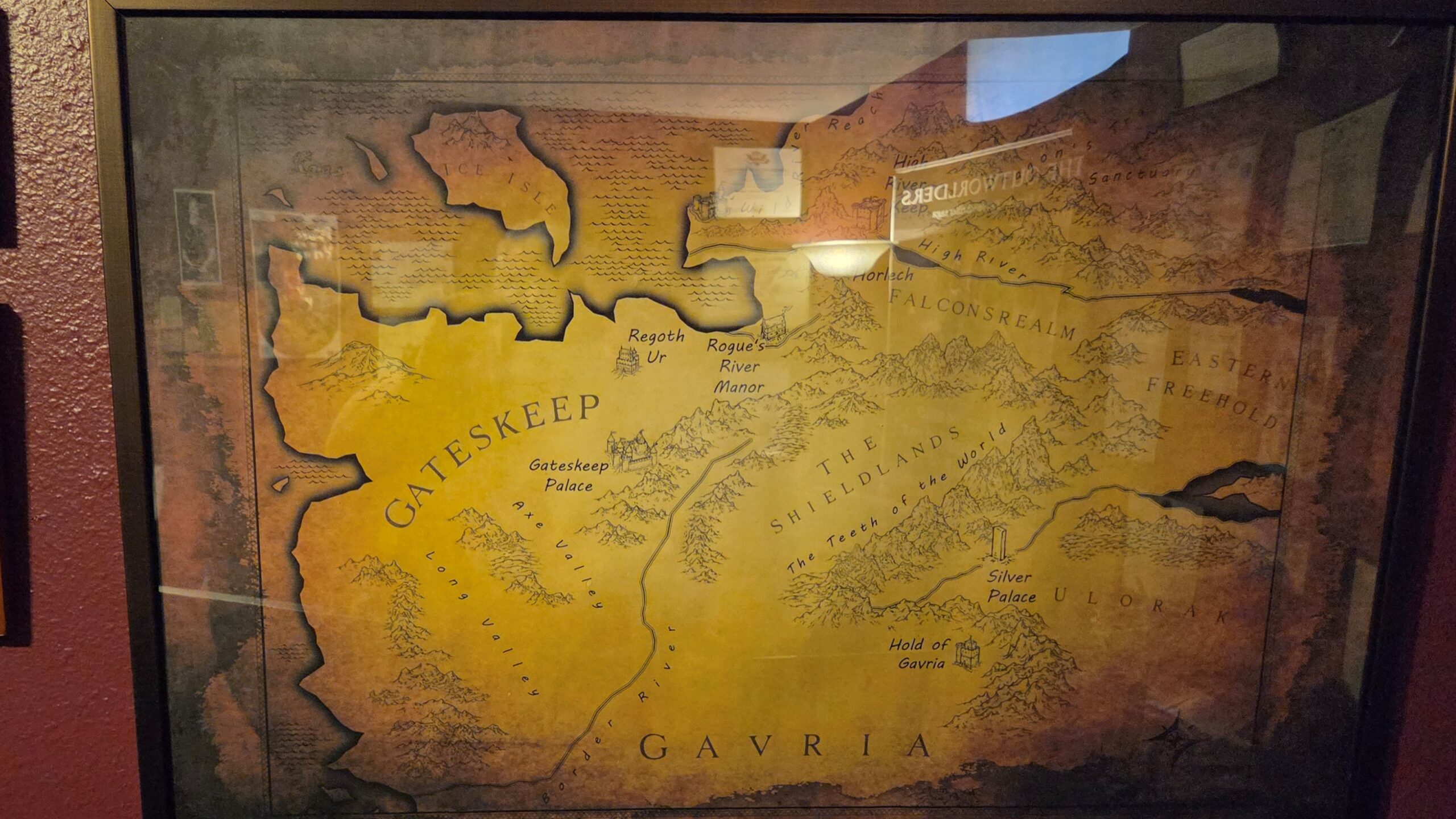
I recently took 3-4 days off from actually writing to generate and then customize an Azgaar's map.
The action in my story takes place in a few far-flung locations, and geography is a key driving force in the world.

I had held off on doing this, knowing that - to some extent - creating a map locks you into staying within its confines. But I'd hit the point where I was no longer sure how far apart locations were, how long travel would take, whether the sun rose behind or to the side of certain mountains, or where a river originated.

Azgaar's is a great tool, I think. I spent quite a bit of time setting up the weather and biomes, and I've just added the handful of locaitons/markers I needed to reorient myself. Not planning to constrain myself by filling in all the empty spaces on the map.
that is so cool i am new to writing so i had no clue i could do that
 
When I started planning my series, the very first thing I did was create a map.

I used the website "Inkarnate". It has really cheap subscriptions, I want to say its like $5 a month?

The tools are incredibly easy to use, and they have thousands of various art assets like houses, castles, trees, mountains etc to place around the map once you have the shape down. It's also easy to make rivers and lakes and stuff.

Once I had my map set it actually really helped me create my cities and then write lore articles for each city because if I put a large city near the coast but also on the mountain range I knew it would be a culture that used ships and the sea etc.

Anyways it was incredibly useful for me over the course of my book planning.

Good luck with your writing!
 

Malik

Auror
I keep a framed 36x48 wall map above my desk for quick reference.

I also sell copies at signings. Readers seem to think it's nifty.

20260605_164217-scaled.jpg
 

Malik

Auror
Also, this, from STONELANDS, which you can find in the book. It's a military SF/fantasy crossover, and having been an intelligence analyst and briefer, I couldn't have written the book without not only a map, but military symbology and graphics for each mission.

I made this up exactly the way I would have made up a 2/3 shop [Ops/Intel[ map, only for the Pentagon to NOPE a few sections.

Messenger_creation_A20E0E6C-E172-4090-AA2F-9FFBDDB91058.jpeg
 

skip.knox

toujours gai, archie
Moderator
Maps:

Size: 600 x 800 is what fits on a Kindle screen or a standard 5.5 x 8.5 book page.

Use bold/thick marks and print. Thinner/fainter lines/text can go missing.

Keep the font size readable. 11 point minimum. 12 or 14 point preferable.

Use a font that people can actually read.
I agree with the last three lines, but I'm pretty sure that print requires better than 600x800. Scale to a larger size for print; you can always downsize for the e-readers. The usual advice is 300dpi, which is not the same as pixel ratios. Here's a reference
Common Map and Book Sizes for RPGs: A Guide to Easy Map-Making for Authors and Creators — ART REALMS
but just an example, a 6x9 paperback would use 1800x2700 pixels. Assuming you want the map to fill that page.
 

ThinkerX

Myth Weaver
I agree with the last three lines, but I'm pretty sure that print requires better than 600x800. Scale to a larger size for print; you can always downsize for the e-readers. The usual advice is 300dpi, which is not the same as pixel ratios. Here's a reference
Common Map and Book Sizes for RPGs: A Guide to Easy Map-Making for Authors and Creators — ART REALMS
but just an example, a 6x9 paperback would use 1800x2700 pixels. Assuming you want the map to fill that page.
600x800 is for Kindle use.

My 600x800 maps did come out fine in the print version.
 

Mad Swede

Auror
600x800 is for Kindle use.

My 600x800 maps did come out fine in the print version.
We've discussed artwork dpi before (here: Book cover artwork DPI) and the general rule is that you should be using as high a resolution as you can for your original artwork, including maps. My publishers guidance is very clear, at least 600 dpi for colour artwork and 1200 dpi for black and white artwork. They also say not to think in terms of screen size (800x600 or whatever), because what is shown on screen can and will be adjusted for an e-book. Yes, this does mean your original digital (or digitised) artwork will result in a big file, but it is always possible to reduce the image resolution before publication. What doesn't work is trying to scale up the image resolution later.
 
Also, this, from STONELANDS, which you can find in the book. It's a military SF/fantasy crossover, and having been an intelligence analyst and briefer, I couldn't have written the book without not only a map, but military symbology and graphics for each mission.

I made this up exactly the way I would have made up a 2/3 shop [Ops/Intel[ map, only for the Pentagon to NOPE a few sections.

Messenger_creation_A20E0E6C-E172-4090-AA2F-9FFBDDB91058.jpeg
You've got it upside down though. With the way the sun moves across the landscape, the top of the map should be labelled South, not North...

Sorry, couldn't resist.

Also, it's very pretty in the way of in-world paraphernalia. It very much emphasises the military nature of the story.

Which is a good thing to realize. Most Fantasy maps as we know them would not exists in the setting which they display. For the simple reason that mapping that accurate and in that manner is a fairly recent invention (with regards to the average fantasy setting at least).
 

Malik

Auror
You've got it upside down though. With the way the sun moves across the landscape, the top of the map should be labelled South, not North...

Sorry, couldn't resist.

Goddamn, that's hilarious. Well done.

Also, it's very pretty in the way of in-world paraphernalia. It very much emphasises the military nature of the story.

Outstanding observation. There's no way they could have known what was important until they got on the ground.

Most Fantasy maps as we know them would not exists in the setting which they display. For the simple reason that mapping that accurate and in that manner is a fairly recent invention (with regards to the average fantasy setting at least).
Absolutely. In THE NEW MAGIC, the Big Bad's "Secret Weapon" is his map room. He had his army pretty much pace off his entire little kingdom, and hired artists to carve wall-sized relief maps. Nobody else in the fantasy world has that kind of fidelity. (He's from Earth.)
 

A. E. Lowan

Forum Mom
Leadership
In THE NEW MAGIC, the Big Bad's "Secret Weapon" is his map room. He had his army pretty much pace off his entire little kingdom, and hired artists to carve wall-sized relief maps. Nobody else in the fantasy world has that kind of fidelity. (He's from Earth.)
That's a bloody super weapon, too. Information where information is sometimes scarce or distorted.
 

A. E. Lowan

Forum Mom
Leadership
Mapping Seahaven is on my list of projects coming right up. Finally found a good mapping program that will handle modern metropolitan models. Now, I get to learn it. :p

Next map is for the next series, Epic Fantasy set at the edge of an Age of Industry with five empires interpreting their own places in this new world. Nothing odd. Just lots of steam and crinoline. Maybe a Priest of the Eternal Sun. An Emperor for the Throne of a Thousand Years. Leviathans. Talking pig. The usual.
 

pmmg

Myth Weaver
I had given consideration to making my map approximate and trying to draw it in a way that made it appear as it might for the period...IE...Not very accurate.

But...That was too much to figure out and Inkarnate already did so much of the work for me. I like approximate as it staves off a lot of questions, but...the master map is the master map.
 

ThinkerX

Myth Weaver
In my worlds...

The Solarian Empire sent out waves of explorers to map much of the known world... which amounts to about a 200-degree swath of the northern hemisphere from just below the Arctic Circle to 10-20 degrees below the equator. Past that... well, they know that some kingdoms extend past the edges of their maps, and are sort of aware of major cities in those regions. There is also an entire ocean that they have heard of but have not mapped. The maps in the books reflect this. At one point, the characters in 'Labyrinth War' come across a trade map of part of the southern ocean and are like, 'wow!'

The second world is different. The primary landmass is the 'Strand,' a narrow ribbon of land usually 20-50 miles wide that wraps around the entire planet, a distance of 25,000+ miles, with abundant peninsulas, bulges, and large offshore islands... but there are also lengthy stretches where it is only a mile or two across. The Strand is ruled by an assortment of nations and city-states, whose people tend to stay put. However, there are bands of pilgrims who wander between mystical 'Shines' set at regular intervals along the Strand, a very few of whom complete the 'full loop.' These pilgrims, while concerned with mysticism, do produce simple yet detailed maps of their travels, which are occasionally made into works of art. So... dig around enough, and you can find or put together maps of the full Strand, though these will have many minor errors or artistic distortions.
 

A. E. Lowan

Forum Mom
Leadership
In my worlds...

The Solarian Empire sent out waves of explorers to map much of the known world... which amounts to about a 200-degree swath of the northern hemisphere from just below the Arctic Circle to 10-20 degrees below the equator. Past that... well, they know that some kingdoms extend past the edges of their maps, and are sort of aware of major cities in those regions. There is also an entire ocean that they have heard of but have not mapped. The maps in the books reflect this. At one point, the characters in 'Labyrinth War' come across a trade map of part of the southern ocean and are like, 'wow!'

The second world is different. The primary landmass is the 'Strand,' a narrow ribbon of land usually 20-50 miles wide that wraps around the entire planet, a distance of 25,000+ miles, with abundant peninsulas, bulges, and large offshore islands... but there are also lengthy stretches where it is only a mile or two across. The Strand is ruled by an assortment of nations and city-states, whose people tend to stay put. However, there are bands of pilgrims who wander between mystical 'Shines' set at regular intervals along the Strand, a very few of whom complete the 'full loop.' These pilgrims, while concerned with mysticism, do produce simple yet detailed maps of their travels, which are occasionally made into works of art. So... dig around enough, and you can find or put together maps of the full Strand, though these will have many minor errors or artistic distortions.
I'd have to put it all together just to see it whole. Reminds me of Heinlein's office. He had the whole timeline of his connected books sprawled across 3 walls. I've only seen one pic but it was inspiring.
 

ThinkerX

Myth Weaver
I'd have to put it all together just to see it whole. Reminds me of Heinlein's office. He had the whole timeline of his connected books sprawled across 3 walls. I've only seen one pic but it was inspiring.
One of the 'art pieces' that I wanted to include in 'Exiles' but didn't was a necklace that was actually a map of the Strand.
 

eom

Dreamer
I am 100% a map guy. I don't write books but screenplays for my film ideas, loads of them in the Fantasy realm, however the concept of maps I think still applies, whether is a book or a script. Having a map, not only is inspiring for the writer, but it also definitely allows for a better development of the story. It gives a clear sense of the world it leaves in and allows for geographical purpose of the character storylines to travel through. Although, in film, you may not necessarily see the world maps, you may actually many times do, either superimposed over the pictures to give the audience geographical reference to expand the Epicness of the characters movements through the world, or you maybe have a scene where a character, deliberately, brings a scroll out and opens it on a table, to find his way somewhere he needs to go, and the camera POV shows it to the audience, informing them then, of the world the story leaves in....many useful ways to use a map also in cinema. And, more than anything, how awesome and joyful it is to make them!
 
Top