• Welcome to the Fantasy Writing Forums. Register Now to join us!

World-building questions about an island chain in the southern Indian Ocean

Miles Lacey

Archmage
At the end of last year I dumped my work in progress. I liked the basic storyline but the worldbuilding aspects just didn't do it for me.

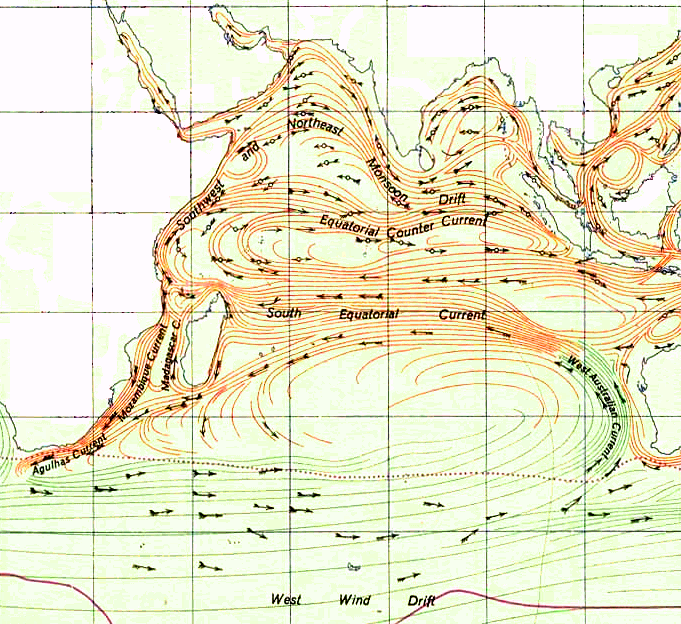
What I have in mind is an island chain made up of islands with the same topography as Sakhalin, Japan and Taiwan stretched out between the southeast coast of Madagascar and western Australia.

The key things I would be interested in knowing would be:

1. What physical characteristics would the people of such islands have?
2. How densely populated would such an island nation be? I strongly suspect that the population of these islands would be a fraction of those who live on the coasts of eastern Africa and South Asia.
3. What crops, livestock and foods could be produced here?
4. What would the climate be like? I envisage a very cold and hostile climate on the parts facing Antarctica and a warmer (temperate?) climate on the parts facing away from Antarctica.
5. Would there still be monsoons in the Indian Ocean? If so, would they be more powerful, less powerful or about the same?

Any feedback would be welcome.
 

Eduardo Ficaria

Troubadour
I think the climate would be influenced not only by the geographical position of those islands, but also by their own geomorphology. If a big island happens to have a really tall mountainous range, that could act as a wall blocking some or most of the humidity coming from one side of the island to the other. That could give you a very insteresting setup that could make two (or more) territories having different climates, and that could lead to war over water or arable land. To see an example of this, check the Andean Mountains.

On the other hand, also be aware that islands tend to become isolated natural environments that can contain endemic species or unique variants of ones known in a nearby continent. Also, species thought extinct in other places of the world could have survived on certain islands. Even more interesting, you could have things like one species having different adaptations (in color, shape, size, etc) due to different evolution paths on each island. This detail could help you make your worldbuilding more colorful.
 

Miles Lacey

Archmage
There is the Kerguelen Islands, but they are a good way south
Kerguelen Islands - Wikipedia
and Réunion that is a lot further north nearer Madagascar.
Réunion - Wikipedia
They might be a place to start.

I had already looked at these islands a few years back and, from a demographic and cultural perspective, Réunion is very useful. The Kerguelen Islands are too far south for the purposes of the world-building but it does make a great place to have a penal colony.

"New Zealand could also be seen as a possible template, or at least a source of ideas for this." - Insolent Lad.

The South Island of New Zealand is a good example of what sort of island I want to use for the world building.

The location is roughly half way between Madagascar and Australia between the Tropic of Capricorn and 30°S. The use of long, skinny and mountainous islands is my plan. Islands for the template include Honshu (Japan), Sakhalin (Russia), Java (Indonesia), Crete (Greece), Luzon (Philippines) and the South Island (New Zealand).
 
Last edited:

Ruru

Troubadour
If it helps at all, the South Island (NZ) wasn't inhabited anywhere near as heavily as the North Island until European settlers arrived, and even then it took a while for numbers to build there.

It is very mountainous, but more than that it's high latitude, and the eastern and souther sides are exposed to the southern ocean. Read as cold and facing very violent storms though winter. Contrast with temperaturs in the high 30s (degC) come summer, and dry as anything.

Things didn't grow well there. Even now it takes massive irrigation and fertilizer to grow more than sheep. Stone fruit and grapes do well tho. With a big mountain range there is lots of erosion, so the soil is very gravelly and doesn't hold moisture. Read as drought problems and big floods.

Big mountain ranges also draw heaps of rain on the prevailing wind side. The South Islands south west corner gets 8m of rain a year. The other coast has frequent droughts.

There's my 2c!
 

Miles Lacey

Archmage
Having travelled around the South Island many times (I'm a Kiwi) I have seen what the weather is like down there. I recall the rainforest on the West Coast and the rain that never seemed to stop (until my last trip there). The fine but freezing weather at Mt Cook which left me bewildered. The howling gales of Cook Strait and the Fouveaux (?) Strait which I loved, apart from the queasiness going to Stewart Island by ferry. The dryness of much of Otago (especially Cromwell) was a surprise and it made that area seem quite monotonous. But nothing compares to travelling to Milford Sound when it"s snowing or raining and you see Mitre Peak in the fog, mist or rain at the end of it. But it was the stifling dry heat of Blenheim I came to hate the most! Give me a decent Wellington southerly roaring off Cook Strait any day!

Indeed it is the diversity of the climate and vegetation in the South Island that interests me so much.

Just don't get me started on those bloodsucking little vampires on the West Coast...!
 
Last edited:

Mad Swede

Auror
I don't know how much you know about the way currents circulate in the Indian Ocean. Generally, in the area you're thinking of placing your island chain there is an east to west circulation and the water temperature is usually somewhere between 16C and 24C, and warmer during the South West (winter) Monsoon. That compares to a water temperature of about 8C to 12C around the South Isalnd in New Zealand. So your islands are likely to have a climate similar to the Azores. Unless your islands are very large they won't affect the monsoon pattern.
 

Miles Lacey

Archmage
I read a fair bit about the monsoons, trade winds and the ocean currents of the Indian Ocean. I agree: the use of smaller islands would not have any impact upon the monsoon seasons but I'm looking at using three large islands that range from the size of Java Island to the size of Honshu island. They are all narrow and very mountainous islands. While I have no doubt that islands this large would have a big impact on the monsoon season I'm not quite sure exactly how.

If the islands were narrow north to south but very long east to west would they act the same way or differently if the islands were laid out with east to west being the narrow part and north to south being the long part?
 

Mad Swede

Auror
We're now getting into some serious oceanography. In reality, a chain of islands like that would require a significant land mass below the water given the depth of the Indian Ocean at those points. That certainly would have an impact on ocean currents and hence on the monsoon. That said, the water would still be warmer than around the South Island and the climate would be milder than NZ, given that your islands would be closer to the Equator than the Azores. I guess it depends on how realistic you want this to be. Most readers won't know oceanography in any detail, so you'd probably get away with assuming a mild climate
 

Miles Lacey

Archmage
When I began to lay out the islands I was thinking of using across the southern part of the Indian Ocean I realised it would change the climate to something I didn't want. The islands being subject to the monsoon has become very important to the story.

I noticed that the area I wanted to put the island had a definite counter-clockwise series of currents surrounding that area. The South Equatorial Current (which would be north of the islands) is warm and flows from east to west. Then it swings downwards near the southeast African coast and joins the West Wind Drift (which would be south of the islands) which is cold and flows west to east. The current then flows upwards along the West Australia Current (which is cold) before joining the South Equatorial Current.

Therefore I reason that for west to east trade ships would traditionally stop at ports on the south coast and for east to west trade they would stop at ports along the northern coast.

This raises a question: Should I use one big, long island or a lot of much smaller islands that form a chain across the Southern Indian Ocean if I want to keep the monsoon?

Indian_Ocean_Gyre.png
 

LAG

Troubadour
Potential for unique biology depending on geological history... think lemurs in Madagascar meet marsupials in Aus(Sorta... Probably marsupials instead of lemur-like beings). Maybe throw in giant birds and lizards, also dodos(cos they tasty.)

I'd wager the biomes at these latitudes would be more subtropical to barrenish shrubland instead of tropical, unless you stretch it north past the Capricorn. I doubt forest cover will be as dense as, say, Reunion or Madagascar. Stunted savanna also possible I guess, much depends on morphology of mountains and how they influence precipitation.

Reunion is volcanic, Mauritius formed by volcanic activity and the area described would be very near the intersections of the Carslberg, SW Indian and SE Indian tectonic ridges... not sure what this means for the island's possible origins or seismic activity, as there is no terra east of Mauritius as is... if a feasible origin, I'm sure the richer soil will aid plant growth and thus biodiversity, though it might mean less initial diversity in fauna depending on when chain formed.

If instead geological remnants from Gondwana split, might be different matter.... will probably have split from antartica/australia and have flora concurrent with those landmasses.

Natives depend on time and mode of colonization---long-established native hominids will be very very unique, though unlikely; otherwise the most feasible probabilities will be either Austronesian drifters who skirted along the Northern Australian coast, or colonists from Madagascar arriving about 1200-3500 years ago. Most likely folk from the Sunda Islands, who populated Madagascar along with various other groups.

Alternatively one can push colonization into more modern eras, most likely with Arabic dhow traders establishing a foothold.

Tropical storms prevalent between the Madagascar-Mozambique strait, not sure how far eastward over the sea they range... I'm guessing you'll get general year-round cold stormy weather instead of seasonal tropical storms.

Factual information about the peopling of Madagascar remains incomplete, but much recent multidisciplinary research and work in archaeology, genetics,linguistics, and history confirms that the Malagasy people were originally and overwhelmingly Austronesian peoples native to the Sunda Islands. They probably arrived on the west coast of Madagascar with outrigger canoes (waka) at the beginning of our era or as much as 300 years sooner according to archaeologists, and perhaps even earlier under certain geneticists' assumptions. On the basis of plant cultigens, Blench proposed the migrations occurred "at the earliest century BCE".  Archaeological work of Ardika and Bellwood suggests migration between 500 and 200 BCE.

The Borobudur Ship Expedition in 2003–2004 affirmed scholars' ideas that ships from ancient Indonesia could have reached Madagascar and the west African coast for trade from the 8th century and after. A traditional Borobudur ship with outriggers was reconstructed and sailed in this expedition from Jakarta to Madagascar and Ghana. As for the ancient route, one possibility is that Indonesian Austronesians came directly across the Indian Ocean from Java to Madagascar. It is likely that they went through the Maldives where evidence of old Indonesian boat design and fishing technology persists until the present. The Malagasy language originated from the Southeast Barito language, and Ma'anyan language is its closest relative, with numerous Malay and Javanese loanwords. It is known that Ma'anyan people were brought as laborers and slaves by Malay and Javanese people in their trading fleets, which reached Madagascar by ca. 50–500 AD. These pioneers are known in the Malagasy oral tradition as the Ntaolo, from Proto-Malayo-Polynesian *tau-ulu, literally 'first men', from *tau, 'man', and *ulu, 'head; first; origin, beginning. It is likely that those ancient people called themselves *va-waka, "the canoe people" from Proto-Malayo-Polynesian *va, 'people', and *waka 'canoe'. Today the term vahoaka means 'people' in Malagasy.
 
Last edited:

Miles Lacey

Archmage
Hmm... Moving the island chain north so it rests between the east coast of Madagascar and the Northwest Cape of Western Australia in the area between 10°S and the Tropic of Capricorn would allow me to keep the tropical environment.

There are three ridges that offer potential island locations: Mid Indian Ridge, Ninety East Ridge and East Indiaman Ridge (northern tip). The only problem with these ridges is that none of them go east-west. They're all north-south (more or less).

An Austronesian based race would work well for me as it will allow me to keep the Polynesian side of things while creating another race that could come from eastern Africa. Maybe African or Arabic peoples? Or even Indians who ended up on the islands because of being shipwrecked or getting lost during the monsoon?

Some very interesting ideas coming across. Keep them coming.

The technology of this world is about that of the 1930s.
 
  • Like
Reactions: LAG

Mad Swede

Auror
When I began to lay out the islands I was thinking of using across the southern part of the Indian Ocean I realised it would change the climate to something I didn't want. The islands being subject to the monsoon has become very important to the story.

I noticed that the area I wanted to put the island had a definite counter-clockwise series of currents surrounding that area. The South Equatorial Current (which would be north of the islands) is warm and flows from east to west. Then it swings downwards near the southeast African coast and joins the West Wind Drift (which would be south of the islands) which is cold and flows west to east. The current then flows upwards along the West Australia Current (which is cold) before joining the South Equatorial Current.

Therefore I reason that for west to east trade ships would traditionally stop at ports on the south coast and for east to west trade they would stop at ports along the northern coast.

This raises a question: Should I use one big, long island or a lot of much smaller islands that form a chain across the Southern Indian Ocean if I want to keep the monsoon?

Indian_Ocean_Gyre.png
OK, in reality the currents change, particularly in the northern part of the Indian Ocean, depending on the monsoon season. The chart you posted is for the summer monsoon. During the winter monsoon there is a much more pronounced east to west flow across most of the ocean and the water is quite a lot warmer, especially in the southern half of the ocean.

Note that the monsoon season is driven by changes in air pressure patterns over the Asian continent. Your island chain wouldn't be large enough to change that.

An island chain of the sort you want will divide the ocean, so what might happen is that there would be cooler water with a west to east current all year round in the southern part of the ocean. That would make the southern side of the islands cooler than the northern side if they are as large as you want them to be (and it wouldn't make much difference if they were on large island or several smaller ones).
 

TheKillerBs

Maester
If you don't want to disturb the ocean currents, you'd have to follow the tectonic plates and place your large islands where there are little currents and use atolls and other small islands in places where the currents pass in real life.
 

Miles Lacey

Archmage
images


A possibility that occurred to me was that the Antarctic Plate boundary could be moved further north (to about 30°S between Madagascar and Australia) and to have the Antarctic Plate pressing against the African and Australian plates rather than pulling away. The resulting uplift would create islands. A string of smaller islands (none larger than Puerto Rico) running from the northwest coast of Australia to the southern coast of Africa would become feasible.

As long as there is the potential for a monsoon climate to exist then it could work.

The next question would be if an Austronesian people could migrate in larger numbers to Madagsscar or even southeast Africa and/or if Africans could migrate in the other direction?
 

LAG

Troubadour
The next question would be if an Austronesian people could migrate in larger numbers to Madagsscar or even southeast Africa and/or if Africans could migrate in the other direction?

I think with the islands being there, Austronesian folk might reach them easier than they did Madagascar, and maybe earlier. RE: African migration, in realistic terms, it is less probable. Most tribes were landlocked and migrated within the continent(what with Africa having so few small islands near its coast, and with the Sahara serving as a barrier after its desertification, naval exploration and the art of oceanfaring boatbuilding wasn't really a thing.)
I'm sure Madagascar could be reached with dugouts from Mozambique et al., but as to faring further east... idk.

But as this is fiction, you can always create a Nguni tribe who relied on shore fishing and over the years improved on naval tech to such an extent that they became early island hoppers. Or, you can have a large Austronesian migration to the Islands, Madagascar and Eastern African coast, introducing their boat tech to the tribes there.

I'm talking from a South African perspective tho, so take what I say with a grain of salt: I am not clued up on early naval history for Tanzania/Madagascar/Mauritius etc.
 

Miles Lacey

Archmage
Madagascar had been settled by both Austronesian and Bantu settlers since ancient times so the ability of Africans to build vessels capable of sailing out to sea is confirmed. Whether or not they could've island-hopped across the Indian Ocean to Australia or southeast Asia remains to be seen as much of this would depend upon how an island chain as proposed in my above post would affect currents and prevailing winds.

I'm starting to see the potential of three distinct groups of people on these islands: Bantu from Madagascar heading east by hopping from island to island, Indians heading south (either by design or by accident) and landing on the islands, and Austronesians heading west along the same islands. The three groups interacting together has a potential to create a new culture that combines Austronesian, Bantu and Indian elements.

Many aspects of the Sunda people (who are believed to have sailed to Madagascar ties in with what I had in mind with the Banjari culture I wanted to create but adding Indian and Bantu influences would enrich such a culture. Only question is what this culture would be like?

Keep the ideas coming!
 
  • Like
Reactions: LAG

Ban

Troglodytic Trouvère
Article Team
When it comes to their meltingpot, the first question I think you should ask is in regards to the timeline. When did each wave of migration come to the island chain? For an example of how multiple waves of migration affects an island culture, I'd suggest looking at Malta. Their traditional language is a latinised semitic language primarily descended from Arabic (one of their oldest settlers), yet the largest religion is roman catholicism (Aragon, Knights of Malta, Napoleonic Empire), while their cuisine (and likely their customs and music as well, I just personally don't know that for sure) is largely inspired by their neighbours in Sicily. And all this being said, their second official language is neither Italian nor French but English (the most recent occupying power). Even older influences such as the Greeks and the Normans have largely faded away, which in itself might be an interesting thing to keep in mind. Not every wave of migration needs to leave a major impact centuries later, especially if even bigger populations move in.

You could follow this example by deriving the basis of your people's language from their earliest (major) source (population), their religion from those who reigned for the longest and their cuisine (+customs, festivals etcetera) from those they are in closest proximity to. How they behave internationally depends on their more recent history. Perhaps you could even add a period under the Omani Empire if you'd like to add even more influences, that might cause your people to use Arabic internationally and would tie them closely to the Arabic-speaking world.
 
Last edited:

TheKillerBs

Maester
A possibility that occurred to me was that the Antarctic Plate boundary could be moved further north (to about 30°S between Madagascar and Australia) and to have the Antarctic Plate pressing against the African and Australian plates rather than pulling away. The resulting uplift would create islands. A string of smaller islands (none larger than Puerto Rico) running from the northwest coast of Australia to the southern coast of Africa would become feasible.

This would absolutely wreck the existing currents and create an entirely new environment within the Indian Ocean. I don't think it would affect the prevailing winds, but the currents would all change.

The bigger issue though is what this means for the world's geologic history. The Antarctic Plate is drifting away from the African Plate, Arabian Plate, Indian Plate, and Australian Plate in the real world. It is also pulling away from the South American Plate in the Atlantic but pushing into it in the Pacific. So, what this tells us (and is confirmed both by the geology and fossil record) is that Africa, the Arabian Peninsula, the Indian Subcontinent, Australia, and South America were all one landmass. If you reverse the course of the Antarctic Plate... what does that do to the world's history? Can you justify the world remaining largely the same with such a huge change?

My suggestion was to keep everything underwater basically the same and simply extend the existing structures (i.e., the midoceanic ridges on the divergent boundary) above water where they'd form volcanic islands a la Iceland. Moving the place of the boundary would change the currents but not much else. The climate would remain largely the same I reckon. Changing the boundary type would create a suspension of disbelief problem that in my opinion is not worth the trouble.
 
Top